


3 more deaths from North Complex Fire; task force preparing for harsher weather conditions
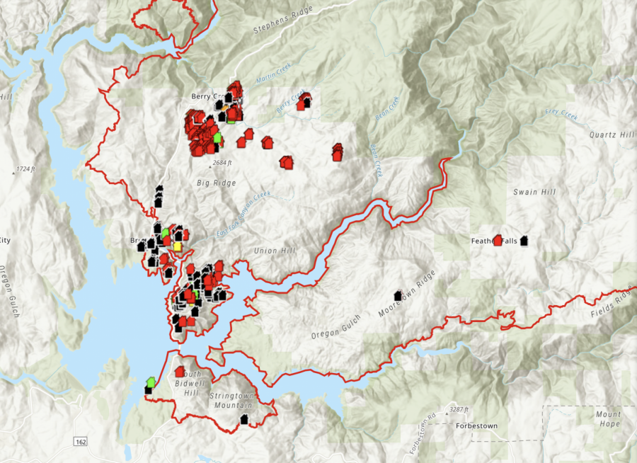
Screenshot of damaged structures from CalFire’s interactive map
Butte County Sheriff Kory Honea confirmed 3 more deaths Saturday, raising the North Complex Fire death toll to 12.
The fire has burned more than 250,000 acres but remains at 21% containment. In the West Zone, 73,000 acres have burned and containment is only 10%. An additional 3,000 acres have burned in that zone since Friday’s update, according to Cal Fire.
News items from Saturday’s community briefing included:
- Brush Creek, Berry Creek and Feather Falls have been the most damaged areas in Butte County
- Butte County has responded to 174 welfare calls; 149 have been found and 13 remain missing
- People who have evacuated can go here to view damage inspection reports of homes and businesses
- 28 major fires or complexes continue to burn in California, with 12 new fires starting since Friday
- 2.8 million acres have burned in California since Aug. 15
- Over 16,000 firefighters and 2,200 fire engines are fighting fires across the state, not including volunteers from Canada and across the country
- 132 single resident structures have been destroyed; 36 commercial buildings and 59 “other” buildings have been destroyed
President Donald Trump will visit Sacramento to receive updates from firefighters and other officials. Trump will hold a press conference with Cal Fire officials in Sacramento’s McClellan Park, a former military base.
Dan Borsum, an incident meteorologist, predicts that weather conditions will change for the worse on Sunday and continue through Monday. A red flag warning could arrive as early as Sunday afternoon.
“There are a number of weather factors that’ll come into better alignment on Monday that are going to make conditions supportive of fire activity,” Borsum said.
Weather changes will bring more sunshine, higher temperatures, increased winds and a drop in humidity. Gusts on Monday may reach 16 to 18 mph. Winds will help clear smoke from the sky, but will also exacerbate fire conditions.
Seven teams of two began damage inspection today during daylight hours. Their information has been uploaded to a data collection app where residents can view their properties. Steve Kaufmann, a spokesman for Cal Fire, said he expects the website to be updated two to three times a day.
“They normally start in the most concentrated area first and they collect damaged, destroyed and non-damaged data,” Kauffman said. “They collect data on an ESRI data collection app and photos are taken of every single property.”
Sheriff Honea hopes to allow escorted evacuees to soon view their properties, take photos for insurance purposes and collect any valuables.
California continues to ask for help from other states.
“The state of California has reached out once again, as we did several weeks ago, to out of state resources, bringing them in to help fill the need not only on this fire but the other fires that are happening in Mendocino and Humboldt County, down in Fresno County, Mariposa County,” said Dave Russell, incident commander of Cal Fire Incident Management Team 4. “So hopefully, in the next few days we will start seeing those resources come in.”
Russell expressed his gratitude to citizens who sought to donate food items, clothing and other products to firefighters.
“What I ask of you, is to take that same support and give it to your neighbor, your friends, and or if they’re not your neighbor or friends,” Russell said, “to the community that has been affected because we still have a lot of people evacuated and we will have a lot of people who will not be going home to their homes.”
Matthew Wreden and Chloe Curtis can be reached at [email protected] or @bymattwreden and @ChloeCurtis__ on Twitter.